Translate Your Page

Showing posts with label Indian Geography. Show all posts

Wednesday, January 09, 2019

Rocks


Rocks:

The solid part of the earth crust is called rocks.

Rocks may not always necessarily be hard.

Minerals are obtained from rocks.

Types of Rocks:

Igneous Rocks:

Igneous rocks are crystalline solids which form directly from the cooling of magma.

This is an exothermic process (it loses heat) and involves a phase change from the liquid(magma) to the solid state.

The earth is made of igneous rock - at least at the surface where our planet is exposed to the coldness of space.

Igneous rocks are given names based upon two things: composition (what they are made of) and texture (how big the crystals are).

These rocks are harder and granular.

There is no layer in igneous rocks and fossils are not found in igneous rocks.

Rocks formed by the cooling of the molten matter beneath the earth surface are called intrusiveigneous rocks and are crystalline rocks.

Sometimes the molten mater comes out on the earth surface and forming extrusive igneous rocks e.g. Obsidian, basalt.

Sedimentary rocks:

They are formed by deposition and sedimentation ofsediments over  a long period.

Sedimentary rocks are called secondary, because they are often the result of the accumulation of small pieces broken off of pre-existing rocks.

Sandstone, limestone, shale are some example of sedimentary rocks.

Metamorphic rocks:

The metamorphic get their name from "meta" (change) and "morph" (form).

The nature of igneous and sedimentary rocks changes due the effects of tremendous heat or pressure and the new transformed rocks are called metamorphic rocks.


Earthquake:

The sudden tremors or shaking or the earth’s crust is called an earthquake.earthquakes:

The earth surface is made up of several plates.

When these moves plates moves, it will leads to earthquake.

Seismology is the branch of Geology which deals with the study of earthquake.

Richter scale is used to measure the magnitude of the earthquake.

Mercalli Scale is used to measure the intensity of the earthquake.

Seismic wave an elastic waves produced in the earth due to the earthquake.

The place where these seismic waves originate beneath the earth’s surface is called the focus the earthquake.

The epicentre is that point on the earth surface which is near to the focus.

Seismic waves are of three types i.e. Secondary waves, primary waves and Surface or long waves.

Volcano:

A volcano is a vent or fissure in Earth's crust through which lava, ash, rock and gases erupt.

The pouring out of the magma or molten rock through ground surface is called volcanic activities.

The opening at the earth surface through which these molten materials comes out with a large force is called Vent.

Types of Volcanic eruptions:

Central eruption:

This type of eruption is sometimes very explosive because the molten material or other materials are ejected through a narrow pipe with greater intensity.

This type of eruption leads to the formation of the conical or dome shaped hills.

Central eruption poured acidic lava.

Mt. kilimanjarao in Africa, Fujiyama in Japan and Vesuvius and mount Etna in Italy are some example of mountains formed due to central eruptions.

Fissure Eruption:

When a large crack or fissure is developed in the ground surface then the hot lava and other material pour out with small speed and slowly.

Lava spread over a large distance.

The poured lava cools down over a period of time and leads to the formation of Basalt Plateau.

In Maharashtra the fertile black regur soil has been formed from basalt rocks.

Mountains:

A mountain is a large landform that stretches above the surrounding land in a limited area, usually in the form of a peak.

A mountain is generally steeper than a hill.

Mountains are formed through tectonic forces or volcanism.

The height of the mountains is greater than 600m.

Types of mountains:

Block Mountains:

Block mountains are created when faults or cracks in the Earth’s crust force materials upward.

Block Mountains usually have a steep front side and then a sloping back side.

Black forest(Germany), Vindhyanchal and Satpura in India, salt range of Pakistan are some example of block mountains.

Fold Mountains:

Fold Mountains are formed when two of the Earth’s tectonic plates collide head on.

Fold mountains are wave like mountains which have numerous peaks and low.

Himalayas, Ural, Alps, Rockies, Andes etc.

Residual Mountains:

Such mountains are formed as a result of weathering. E.g. Aravali, Nilgari, Parsnath Hills.

Accumulated Mountains:

These are formed due to accumulation of sand, soil, rocks, lava etc. on the earth crust, e.g. Sand Dunes.

More from us:


All the Important Rivers


River

River is the biggest source of water. Rivers provide us water to drink, irrigation, electricity, cook, clean things and easy & cheap transportation.  It is also a source of fresh water that flowing naturally towards an ocean, lake, sea or another river. Rivers flow in channels. The bottom of channel is called the bed and sides of the channel are called the banks. Sometimes a river flows into the ground and becomes dry at the end of its course without reaching another body of water.

Rivers begin at their source in higher ground such as mountains or hills, where rain water or melting snow collects and forms tiny streams. When one stream meets another and they merge together, the smaller steam is known as a tributary. It takes many tributary streams to form a river.

As a river flows, it carries along material or debris, called its load. A river’s load includes rocks, stones and other large particles, which are washed along the river bed.  Finer particles float in the water. A river grows larger as it collects water from more tributaries along its course. The river ends at a mouth. In larger rivers there is often also a wider floodplain shaped by flood waters over-topping the channel. Floodplains may be very wide in relation to the size of the river channel.

Important Rivers in World:-

There are so many rivers in all over world. The rivers are determined by its length.  The River Nile is the longest riverin the world. It measures 6,695 kilometers from its source Burundi, along the White Nile, to its delta on the Mediterranean Sea. Officially, the shortest river is the D River, Oregan, USA, which is just 37 meters long.

The biggest river in the world is the Amazon, measured by the amount of water that flows down in it. On average 120,000 cubic meters of water flows out of its mouth every second.

The longest river of Europe is the River Volga. It flows primarily in a southerly direction through Russia into the Caspian Sea.

Important Rivers in India:

The important rivers of India are Ganga, Yamuna, Brahmaputra, Indus, Mahanadi, Godavari, Krishna, Kaveri, Narmada and Tapti.

Ganga: Ganga is the most holy river according to Hindu. It has started from the Gangotri in the Himalayas and poured into the Bay of Bengal by travelling of around 2525 km. It is ranked 3rd largest river in the world. There are a number of cities had been developed across the banks of Ganga like Pataliputra, Kashi, Allahabad, Varanasi, Kolkata etc. It had also created the World’s largest delta in West Bengal named as Sundarban delta.

Yamuna: Yamuna River had originated from Yamunotri Glacier in the Himalayas, then travels across several states and merged into the Ganga at Triveni, Allahabad. Its total length is 1376 km. Yamuna River’s water contributed nearly 70% of Delhi’s water supply. The Taj Mahal is situated on the banks of Yamuna River.

Brahmaputra: Brahmaputra River is originated from Angsi Glacier, the northen Himalayas in Tibet, then entered into the Arunachal Pradesh to Assam and then merges with the Padma river in Bangladesh. Its length is around 2900 km and plays an important role in the irrigation and transportation. It emptied into the Bay of Bengal.

Indus River: The Indus River is a historically famous in Asia. It originated from the Tibetan Plateau, and then flows through the Ladakh then entered into Pakistan and finally merge into the Arabian Sea after travelling a distance of 3180 km.

Mahanadi River: Mahanadi is a major river in the state of Chhattisgarh and Odisha. Mahanadi’s water is used in the irrigation and drinking purpose, it is also called the ruin of Orissa due its devastating floods over the years but till Hirakud Dam was constructed. Its total length is 858 km.

Godavari: Godavari is the longest river in the southern India and 2nd largest in India after Ganga. It is originated from Maharashtra and flows through Andhra Pradesh, then merges into the Bay of Bengal after travelling a distance of 1465 km.

Krishna: The 3rd longest river in India after Ganga and Godavari, Krishna River which is originated from Mahabaleswar in Maharashtra and flows through the state of Karnataka, Andhra Pradesh and finally merges into the Bay of Bengal by travelling a distance of 1400 km.

Kaveri: The Kaveri River is one of the large rivers in India which is originated from Talakaveri in the Western Ghats of Karnataka and flows through the states of Karnataka & Tamilnadu, finally merges into Bay of Bengal by travelling a distance of 765 km.

Narmada: Narmada River is the 5th Longest in the Indian sub-continent. It is also called the Life line of Madhya pradesh due to its huge contributions. Narmada River is originated from Narmada Kund, Amarkantak in Madhya Pradesh and merges into the Arabian Sea near Gujarat after travelling a distance of 1312 km.

Tapti: Tapti River is one of the major rivers in Central India. Its total length is around 724 km which flows through the states of Gujarat, Madhya Pradesh and Maharashtra and finally merges into the Gulf of Cambay of Arabian Sea near Gujarat.


Water Transport


India has an extensive network of inland waterways in the form of rivers, canals, backwaters and creeks. The waterways of the country have been divided into internal waterways and oceanic waterways.

The following waterways have been declared as National Waterways:

NW1Allahabad to Haldia - 1620 Km

NW2- Sadia to Dhubri on Brahmaputra River - 891 Km

NW3Kollam to Kottapuram - 168 km

NW4- Kakinada to Marakkannam along Godavari and Krishna river - 1095 km

NW5- Mangalgarhi to Paradeep and Talcher to Dhamara along Mahanadi and Brahmini - 623 Km

12 - Major Ports in India
Western Coast

Tidal Port – (Child of Partition) – Gujarat

Mumbai – (Busiest and biggest) - Maharashtra

JL Nehru- (Fastest growing) - Maharashtra

Marmugao – (Naval base also) – Goa

Mangalore – (Exports Kudremukh iron–ore) – Karnataka

Cochin – (Natural harbour) – Kerala

Eastern Coast

Paradip - (exports raw iron to japan) - Odisha

Vishakhapatnam – (deepest port) – Andhra Pradesh

Chennai – ( Most modern in private hands) – TamilNadu

Ennore – (Most modern in Private hands) - Tamil Nadu

Tuticorin - (Southernmost) – Tamil Nadu

Port Blair – (Strategically important) - Andaman andNicobar Islands

Air Transport
JRD Tata was the first person to take a solo flight form Mumbai to Karachi in 1931.

In 1935, the ‘Tata Air Lines’ started its operation between Mumbai and Thiruvananthapuram and in 1937 between Mumbai and Delhi.

In 1953, all the private airline companies were nationalized and Indian Airlines and Air India came into existence.

Vayudoot Limited started in 1981 as a private air carrier and later on it merged with Indian Airlines.

International Airports Authority of India and National Airports Authority were merged on 1995 to form Airports Authority of India.

The Authority manages the Civil Aviation Training College at Allahabad and National Institute of Aviation Management and Research at Delhi.

12 - International Airports in India

Rajiv Gandhi International Airport – Hyderabad

Calicut International Airport – Calicut

Chhatrapati Shivaji International Airport - Mumbai

Kempe Gowda International Airport – Bengaluru

Goa Airport in Vasco di Gama city - Goa

Netaji Subhash Chandra Bose International Airport – Kolkata

Thiruvananthapuram International Airport – Thiruvananthapuram

Lokpriya Gopinath Bordoloi International Airport – Guwahati

Sardar Vallabh Bhai Patel International Airport – Ahmedabad

Indira Gandhi International Airport – Delhi

Chennai International Airport – Chennai

Shri Guru Ram Dass Jee International Airport – Amritsar


Important Notes on Indian Soil and Agriculture


Types of Soil

India is an Agrarian country & Soil is its prime resource. It plays a vital role in the economy of India as our industries are mainly Agro-based.

About 65 to 70% of the total population of the country is depended on agriculture.

Generally, there are six types of soil found in India

Alluvial Soil

Regur or Black Soil

Red Soil

Laterite Soil

Desert Soil

Mountain Soil

1. Alluvial Soil

Deposition of materials by sea and river is calledalluvium and the soil formed due to deposition of alluvium is called as alluvial soil.

This type of soil mainly found in the Indo-Ganga and Brahmaputra plain i.e. the whole northern plain and in some parts of the river basin in the south and some plateau region.

This soil is also found in the deltas of the Mahanadi, Godavari, Cauvery and Krishna.

Alluvial soil can be broadly categorised in two types i.e. New alluvial soil and old alluvial soil.

Old alluvial soils are found in slightly elevated areas far away from the river and are clayey and sticky.

The new alluvial soil is found in the floodplain of the river and is much fertile in comparison to the old alluvial soil.

Crops Grown: Alluvial soil is suitable for the rabi and kharif crop like cereals, cotton, oilseeds andsugarcane.

2. Regur or Black soil

The regur or black soils have developed extensively upon the Lava Plateaus of Maharashtra, Gujarat, Madhya Pradesh mainly Malwa and are formed due to volcanic activities.

These soils are very fertile and contain a high percentage of lime and a moderate amount of potash.

The type of soil is especially suited for the cultivation of cotton and hence sometimes called ‘black cotton soil.’
Crops Grown: Cotton, Jowar, Wheat, Linseed, Gram, Fruit and Vegetable.

3. Red Soil

 Red soils develop on granite and geneses rocks under low rainfall condition i.e. due to weathering of the metamorphic rocks.

These soils are red in colour due to the highconcentration of Iron Oxide.

 These soils are friable and medium fertile and found mainly in almost whole of Tamil Nadu, South-eastern Karnataka, North-eastern and South-eastern Madhya Pradesh, Jharkhand the major parts of Orissa, and the Hills and Plateaus of North-east India.

These soils are deficient in Phosphoric acid, organic matter and nitrogenous material.

Crops Grown: Wheat, Rice, Millet's, Pulses.

4. Laterite Soil

 Laterite is a kind of clayey rock or soil formed under high temperature and high rainfall and with alternate dry and wet period,.

Laterite and lateritic soils are found in South Maharashtra, the Western Ghats in Kerala and Karnataka, at places in Odisha, small parts of Chottanagpur and  in some parts of Assam, Tamil Nadu, Karnataka, and in western West Bengal (particularly in Birbhum district).

Crops Grown:

This type of soil is unsuitable for agriculture due to the high content of acidity and inability to retain moisture.

5. Desert soil

This type of soils found in Rajasthan, Haryana and the South Punjab, and are sandy.

In the absence of sufficient wash by rainwater, soils have become saline and rather unfit for cultivation.

 In spite of that cultivation can be carried on with the help of modern irrigation.

Wheat, bajra, groundnut, etc. can be grown in this soil.

This type of soil is rich in Phosphates and Calciumbut deficient in Nitrogen and humus.

6. Mountain Soil

Soil found in higher altitude on the mountain is called as Mountain soil.

The characteristics of this type of soil are changed according to the altitudes.

This type of soil is suitable for the cultivation of potatoes, fruits, tea coffee and spices and wheat.

Types of Agriculture in India

There are different types of farming activities performed in India which are as follows:

Subsistence Farming

Subsistence farming is a type of farming in which nearly all the crops or livestock raised are used to maintain the farmer and farmer’s family leaving little.

Subsistence farms usually consist of no more than a few acres, and farm technology tends to be primitive and of low yield.

Mixed farming

Mixed farming is an agricultural system in which a farmer conducts different agricultural practice together, such as cash crops and livestock

The aim is to increase income through different sources and to complement land and labour demands across the year.

Shifting cultivation

Shifting cultivation means migratory shifting agriculture.

 Under this system, a plot of land is cultivated for a few years and then, when the crop yield declines because of soil exhaustion and the effects of pests and weeds, is deserted for another area.

Here the ground is again cleared by slash-and-burn methods, and the procedure is repeated.

Shifting cultivation is predominant in the forest areas of Assam (Known as jhum), Meghalaya, Nagaland, Manipur, Tripura, Mizoram, Arunachal Pradesh, Madhya Pradesh, Orissa and Andhra Pradesh (Podu).

Extensive Farming

This is a system of farming in which the farmer uses the limited amount of labour and capital on a relatively large area.

This type of agriculture is practised in countries where population size is small and land is enough.

Per acre yield is low but the overall production is in surplus due to less population.

Here machines and technology are used in farming.

Intensive Farming

This is a system of farming in which the cultivator uses a larger amount of labour and capital on a relatively small area.

This type of farming is performed in countries where the population to land ratio is high i.e. population is big and land is small.

Annually two or three types of crops are grown over the land.

Manual labour is used.

Plantation Agriculture

In this type of agriculture, cash crops are mainly cultivated.

A single crop like rubber, sugarcane, coffee, tea is grown.

These crops are major items of export.


IMPORTANT TEMPLES OF INDIA


Temple which is called “Mandira” in Sanskrit is a house of workship. Temples in India reflect the cultural glory and history of a place.

In India, temple is considered as a place where human spiritually connect with God. Temples are built on the principles of vastushastra, known as “Shilpa Shashtra”. It is a symbolic, miniature representation of the cosmos.

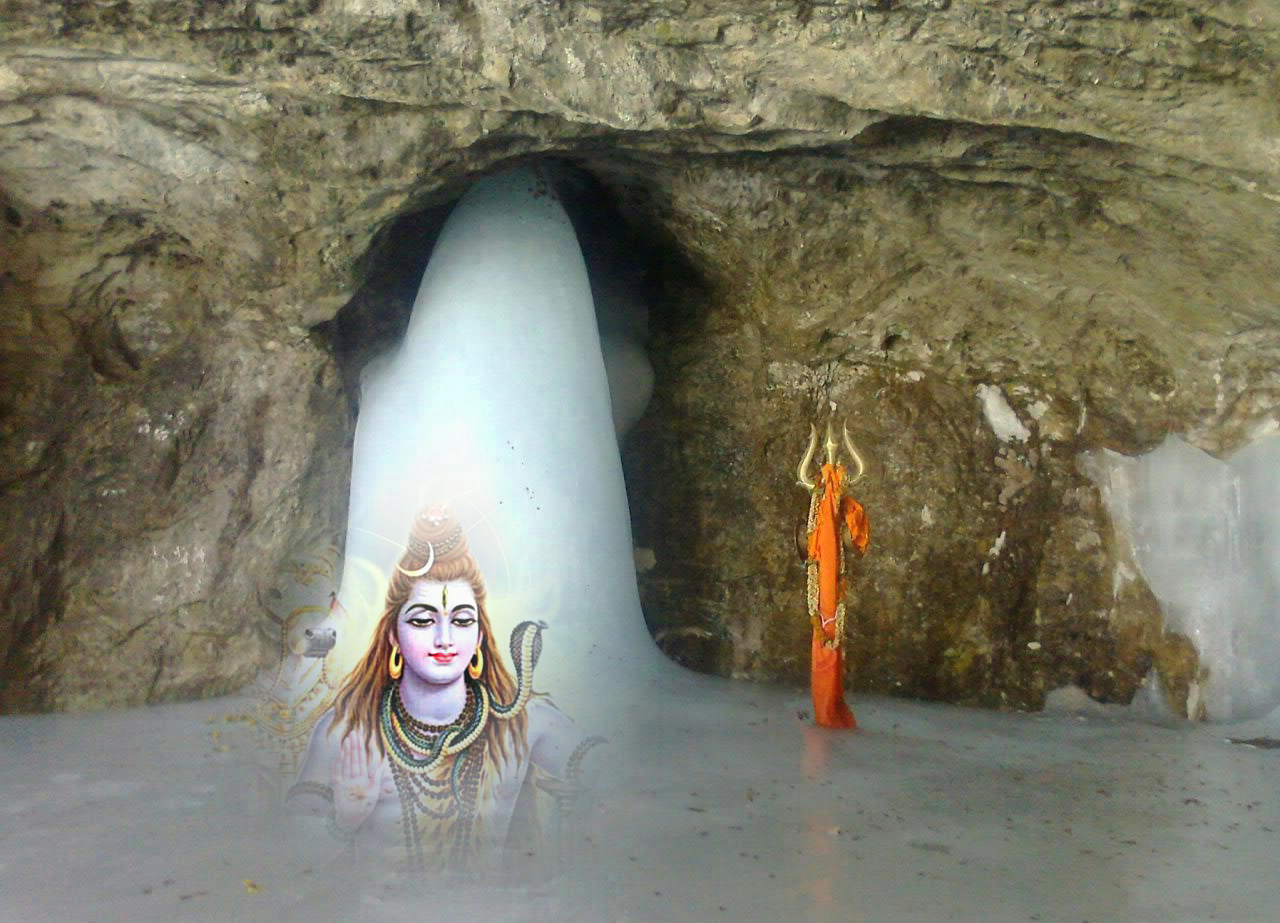
1. Amarnath Temple

Located at- Jammu and Kashmir

Discovered- 150 years ago.

Primary Deity-  Lord Shiva

Famous For- The temple is famous for lord Shiva’s Linga which is in the cave. The cave is situated at an altitude of 3,888 m  (12,756ft), about 141 km from Srinagar and one can reach through Pahalgam Town. The cave is covered with snow whole year except for a short period of time in summer when it is open for pilgrims.


The cave waxes during May to August, as snow melts in the Himalayan above the cave and the resultant water seeps into the rocks that form the caves. It is also claimed that the Shiva Linga grows and shrinks with the phases of moon, although there is no scientific evidence for this belief.

It is also claimed this is the cave where shiva explained the secrecy of life and eternity to his divine consort, Parvati. Two other ice formation’s also represent Load Ganesha.

There is a annual pilgrimage for this cave to workship the ice stalagmite Lingam.


Yatra- The beginning of the annual pilgrimage, called Amarnath Yatra is marked by ‘pratham pujan’ to invoke the blessings of Shir Amarnathji. It is a popular yatra destination for Hindus. Pilgrims visit the holy place during the 45 days season around the festival of Shravani Mela in July- August.

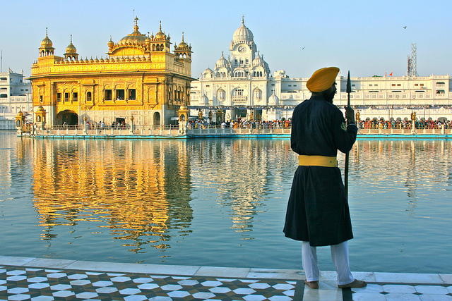
2. Golden Temple

Located at – Amritsar, Punjab

Built in – Dec 1585 AD and completed in 1604

Primary Deity-  Sri Harmandir Sahibs

Founded in 1574 by the fourth Sikh Guru, Guru Ram Das, the fifth Guru, Guru Arjan designed the Harmandir Sahib to be built in the center of this holy tank.

Famous For- The gurudwara is surrounded by the large lake and it is believed that it consists Amrit and is fed by the Ravi River and by this name Amrit the city named “Amritsar”. There are four entrances to the gurudwara which signifies the importance of acceptance and openness of all the religions regardless of their colour, creed or gender. Maharaja Ranjit Singh was a major donor of wealth and materials for the shrine and he is the person who platted the Temple with Gold in 1830, hence it is called “Golden Temple”.

While visiting the temple, the devotees are requested to dress well in the temple, wearing head covering which is a sign of respect to the lord, Not wearing shoes. One should sit on the ground while in the Darbar Sahib as a sign of deference to both the Guru Granth Sahib and God.


Langar- It is called Guru ka langar. It has ensured participation of women and childrens in task of service for mankind. Women plays an important role in the preparation of meals and children help in serving food to the devotees.


It is very generous, that everyone is welcomed in the Langar. Each family prepare food for a week and feed thousands of people daily. All the preparation, the cooking and the washing up is done by the helpers in the temple. The langar is free of cost for all, the temple get fund from the deposit from pilgrims.

3. Markandeshwar Temple

Located at- Shahbad Markanda, Dist- Kurukshetra, Haryana

Primary Diety- Lord Shiva and Markandeya

Built in- 12th Century AD

Famous for—The temple is said to be at the place where Markendeya worshiped at the time of his destined death at the tender age of 16 years. He wished to win over Lord Yama, the God of death and change his destiny. When Yama came to take his life, he clung to Shiva Linga and the noose fell over the Lingam. Lord Shiva appeared and pierced Yama with a trident and saved his devotee. And Shiva blessed Markandeya to live immortal life as Chiranjeev.


The temple is made of marble and has an exterior arch welcoming pilgrims. It has a Shiva Linga with Lord Shiva’s idol and young Markandeya in a prayerful posture. The walls of the temple depict a scene of Lord Shiva saving the child Markandeya from Yama, the Lord of death.

Pilgrims visit the temple in large numbers in the month of Shravan (July/August).

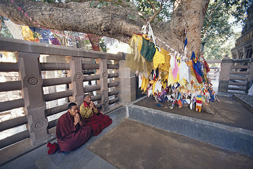
4. Mahabodhi Temple

Located at- Bodhgaya, Bihar

Discovered – 260 BC

Architect- Ashoka

Primary Deity- Lord Buddha

Famous For- Mahabodhi Temple is a Buddhist Stupalocated at bodhgaya, 116km from Capital of Bihar, Patna. The temple is built in bricks and which is still survives today. The ground level of the temple is 45 meters square, stretching up in a pyramid shape that ends in a smaller square platform. The central tower of Mahabodhi stands 180 feet (54 meters) tall. The brickwork on the outside of the temple depicts scenes from the life of the Buddha.


Inside the temple is a colossal image of a seated Buddha touching the earth with his right hand (a gesture known as the earth-witness mudra). In this posture the Buddha accomplished the supreme enlightenment. The statue is of black stone but it has been covered in gold and dressed in bright orange robes. The temple covers an area of nearly 4.8 hectares and 55 m in height.

Bodhi Tree- Immediately next to the Mahabodhi Temple is the Bodhi Tree, a descendent of the very tree under which the Buddha was enlightened, and the Jewel Walk, marking the place where the Buddha is said to have practiced walking meditation for seven days after his enlightenment.


In 2002, Mahabodhi Temple, located in Bodh Gaya, became a UNESCO World Heritage Site.

5. Birla Mandir

Located at- Jaipur, Rajasthan

Built in – Year 1988, by Birla Group of Industries.

Primary Deity- Lord Laxmi Narayan

Famous for-  Originally it is known as Lakshmi Narayan Temple and it is situated below the Moti Dungri Fort in Jaipur. It is dedicated to Lord Vishnu and Goddess Lakshmi. Built in pure white marble, it is built with modern approach. Inside the temple, Lord Vishnu and Goddess Lakshmi idols can be seen.


Temple represent architectural beauty as its delicate carving of Hindu symbols and ancient quotes from the Geeta and Upanishads ornaments the walls of the temple. Apart from religious idols, pictures and figures of several religious saints, philosophers and historical achievers, like Socrates, Buddha, Zarathustra and Confucius, are also included in the temple.

The best time to visit this temple is between the months of October to March. In this temple, 'Janmashtami', the birth anniversary of Lord Krishna, is celebrated with great enthusiasm.

6. Somnath Temple

Located at – Prabha patan near Vereval in Saurashtra, Gujarat

Opened – May 1951

Built by-  Shri. Vallabhbhai Patel (latest)

Primary Deity- Lord Shiva

Famous For- Meaning of Somnath is the protector of God Moon. Somnath Temple is also known as Prabhas Patan, Deo Pattan or Somnath temple and the Shrine Eternal. It is one of the 12 jyotirlinga Shrines of God Shiva.


It is believed that the temple is built by King Somraj, the moon god out of gold. It was rebuilt by Ravana in silver. Again Lord Krishna built in wood. The apex of temple rises to a height of 155 feet. There is a kalash (pot vessel) on the top, which measures 10 tons. The flag mast on this pinnacle is 37 feet long and is changed thrice during the day. The temple is situated at very extraordinary place there is no land in between Somnath Seashore to Antartica.

Somnath Temple was destroyed  many times by various rulers and kings. But few kings of Gujarat renovated this temple too many times. In 1947 Sardar vallabhbhai Patel renovated Somnath Temple.

Somnath is famous for its architechture, the present temple, kailash Mahameru Prasada is built in the chalukya style of temple architecture and reflects the inherent skill of Sompuras,Gujarat’s master masons.

7. Siddhivinayak Temple

Located at – Prabhadevi, Mumbai, Maharashtra

Year Built- November19, 1801, by professional contractor, late Mr. Laxman Vithu Patil

Primary Deity- Lord Ganesha

Famous For- Late Deubai Patil who was a rich lady of Agri Samaj from Matunga. Although she was rich but had no child. So she humbly request lord ganesha “Although I cannot have a child, let other ladies who are childless get the pleasure of child on visiting the temple and praying you”. Looking at the successful subsequent history of the temple, it appears like Ganesha nodded. Therefore, it is famous for “Navasacha Ganapati” in Marathi.


The idol of Shree Shidhivinayak was carved out of a single black stone and 2’6 (750mm) and 2’ (600mm) wide with the trunk on the right. This is rather unusal appearance of Lord Ganesha. The upper right and left hands hold a lotus and an axe respectively, while the lower right and left hands hold a rosary (japmala) and bowl full of “Modak” respectively. On both sides of the Lord Ganesha Idol, idols of Riddhi and Siddhi goddesses who are appearing like peeping out from Ganesha Idol from behind.


Types of Winds


Winds:

The Wind is the movement of air caused by the uneven heating of the Earth by the Sun.

Sometimes the wind blows gently, refreshing us. At other times, it blows strongly creating storms that cause widespread damages.

We need measurements of two quantities: direction and speed, to give a description of the wind.

Types of Winds:

Trade Winds:

A wind blowing steadily towards the equator from the north-east in the northern hemisphere or the southeast in the southern hemisphere, especially at sea.

They blow from the Subtropical High-Pressure Belt to the Equatorial Low-Pressure Belt in the tropics between 30°. North and 30° South latitudes.

They blow as the N.E. Trades in the Northern Hemisphere and as the S.E. Trades in the Southern Hemisphere.

The name "Trade" is derived from a nautical expression "to blow tread" meaning to blow along a regular path or "tread".

Westerlies:

They blow from the Sub-tropical high-Pressure Belt to the Sub-polar low-Pressure Belt in the temperate latitudes between 30° and 60°, on either side of the Equator.

They are more constant and stronger in the Southern Hemisphere because there are no large landmasses to interrupt them.

In places, they become so strong that these winds are known as the Roaring Forties or the Brave West Winds and the Furious Fifties.

The belts of the Westerlies move north and south following the Sun's movement. These are known as Westerlies because they blow out of the west.

 Polar Winds:

They blow from the Polar High-Pressure Belt to the Subpolar Low-Pressure Belt between latitudes 60° and the poles on both sides of the Equator.

They winds blow from the east to form the Polar Easterlies.

They are more regular in the Southern Hemisphere.

Polar winds are extremely cold and dry.

Climatic Winds or Periodic Winds:

These winds change their direction along with a change in time or change in climate.

Land and sea breezes and the Monsoon winds are typical examples of periodic winds.

Monosoon Winds:

Monsoon winds are seasonal winds characterized by a complete reversal in their direction from one season to another.

They blow from the sea to the land in summer.

They blow from the land to the sea in winter.

Forests:

They are of the following types:

Tropical Evergreen Rain Forests:
Such forests are found in the equatorial and the tropical regions with more than 200 cm annual rainfall. The leaves of trees in such forests are very wide. Ex-Red wood, palm etc.

Tropical Semi-Deciduous Forests:
Such forests receive rainfall less than 150 cm. Sangwan, saal, bamboo etc. are found in such forests.

Temperate mixed Forests:
Such forests are a mixture of trees and shrubs. Corks, Oak etc. are the major trees of these forests.

Coniferous Forests or Taiga:
These are evergreen forests. The trees, in these forests, have a straight trunk, conical shape with relatively short branches and small needle-like leaves. Example-Pine, Fir etc.

Tundra Forests:
Such forests are covered with snow. Only Mosses, a few sledges and Lichens grow here in the summers. This type of vegetation is chiefly confined to the northern hemisphere (e.g. in Eurasia, North America, and Greenland Coast).

Mountainous Forests: Vegetation varies according to altitude.

Pastures (or Grasslands):

They can be divided into two types:

Tropical Pastures and

Temperate Pastures

Tropical Pastures: They have different names in different countries.

Savanna in Africa,

Campos in Brazil,

Lanos in Venezuela and Columbia.

Temperate Pastures:

They are known by the following names-

Prairies in USA and Canada,

Pampas in Argentina,

Veld in South Africa,

Rangelands or Downs in Australia and Newzealand

Steppes in Eurasia (Ukraine, Russia).

Physical Divisions of the Indian Subcontinent

A chain of high mountains radiates out from thePamir Knot which lies just in the north of India.

In these mountains, the Hindukush, the Sulaiman, and the Kirthar in the East and the Himalayas in the west separate the Indian subcontinent from rest of Asia.

Indian subcontinent can be divided into following physical divisions:

The Great Mountain Wall of the North

The Great Northern Plains

The Great Peninsular Plateau

The Coastal Plains

The Great Indian Desert

The Island Groups.

The Great Mountain wall of the North:

The Himalayas, the highest mountain wall of the world, are situated on the northern boundary of India like an arc.

From west to east the Himalayas are 2500 km long. The average breadth of the Himalayas is between 250 km to 400 km.

Mount Everest, the highest peak in the word, lies in these mountains in Nepal.

Division of the Himalayas

The Himalayas consist of three parallel mountain ranges:

(i) The Greater Himalayas

(ii) The Lesser Himalayas and

(iii) The Outer Himalayas.

The Greater Himalayas (or Himadri)

This is the loftiest of the three ranges of Himalayas.

Mount Everest lies in this range.

These snow-covered mountains give birth to many glaciers.

The Ganga originates from this glacier.


The Leasser Himalayas (for the Himachal Himalayas):

South of the Greater Himalayas, the range also lies parallel to it from west to east.

This ranges 60 to 80 km wide and its average height ranges between 3500 to 4500 meters.

Tourist centers like Shimla, Mussoorie, and Nainitalare situated in this range

The Outer Himalayas (or Shiwaliks):

This is the southernmost and the third parallel range of the Himalayas with an average height of 900 to 1200 meters.

Its breadth is only 10 to 15 km. Shivalik range is broader in the west.

Heights of Major Mountain Peaks in India


*represents the mountains situated in PAK.


The Great Nothern Plains:

The Northern plains are divided into three sub-divisions. These are the Punjab and Haryana plains. The Ganga plains and the Brahmaputra valley.

The Ganga plains form the largest lowland drained by thy Ganga and its tributaries.

The Yamuna is the most important tributary of the Ganga.

The Ghaghara, the Gandak, the Kosi and the Tista are other tributaries of the Ganga.

The Sone and the Damodar are tributaries of the Ganga while the Chambal and the Betwa are tributaries of the Yamuna from the peninsular plateau.

The Ganga plain has an extremely gentle slope. Parts of the plain are subject to floods in the rainy season. In the lower course, the Ganga divides itself into tributaries to form a large delta along with the Brahmaputra.

The Punjab and Haryana plains represent a part of the Indus basin.

A low watershed separates these plains from the Ganga plains.

The Great Pensinsular Plateau:

Anamudi or Anaimudi (2695 m) is the highest peak of the Peninsula.

The Deccan plateau includes the area to the south of the Vindhyas.

The western edge of the plateau rises steeply from the Arabian Sea to form the Western Ghats (which includes the Shahydri).

The Deccan plateau slopes gently towards the east. The surface of the plateau is dissected into a rolling upland by a number of rivers.

The elevation ranges from 300 to 900 meters.

The eastern edge of the plateau is known as theEastern Ghats.

The north-western region of the Deccan plateau is covered by nearly horizontal sheets of lava.

This region is called 'Deccan trap region'. The Deccan plateau is drained by many long east flowing rivers.

These rivers originate in the Western Ghats, flow towards the east and enter the Bay of Bengal.

The Godavari, the Mahanadi, the Krishna and the Cauvery are the major rivers that have built deltas along the coast.

The Narmada and the Tapti rivers are west flowing.

Both the rivers enter the Arabian Sea along the Gujarat coast.

These rivers do not have deltas.

Major Plateaus: Marwar Upland, Central Highland, Bundelkhand, Malwa Plateau, Baghelhand, Chhotanagpur Plateau (Hazaribagh Plateau, Ranchi Plateau, and Raj Mahal Hills), Meghalaya Plateau, Deccan Plateau, Maharashtra Plateau, Karnataka Plateau, Telengana Plateau, Chhatisgarh Plain.

The Coastal Plains

Narrow strips of flat land on eastern and western coasts are known as the East Coastal Plain and theWest Coastal Plain respectively.

The West Coastal Plain

This plain which lies between the Arabian Sea and the Western Ghats spreads from Gujarat in the north to Kanyakumari in the south.

It is broader in the north and narrower in the south. This uneven plain has been dissected by many fast-flowing rivers.

Its northern part from Gujarat to Goa is called Konkan, while southern part from Goa to Kanyakumari is known as Malabar. Several lagoons (salt water lakes separated from the main sea by sandbars and spits) are found on the coastal plain.

Important ports developed on its coast from north to south are Kandla, Mumbai, New Jawahar Port Mumbai, Marmagao, Mangalore, and Cochin.

The East Coastal Plain:

This broader coastal plain spreads along the Bay of Bengal from Odisha in the north to Kanyakumari in the south.

Its northern part is known as Northern Circar plainsand the southern part is called Coromandel Coast.Rivers like Mahanadi, Godavari, Krishna and Cauvery form deltas on this plain.

This coast is famous for rice cultivation.

A large number of lagoons are also found here.

Chilka and Pulicat lakes are fine examples of lagoons on our east coast.

The Great Indian Desert:

It lies to the west of the Aravali range.

It extends over major part of Rajasthan and Sindhi in Pakistan.

This desert does not get much rain as the Aravali range run parallel to the south-western monsoon winds.

It is in the rain shadow area of the Bay of Bengal current.

Lake Sambhar is found here.

The Island Groups

Lakshadweep is a group of 36 coral islands in the Arabian Sea.

It is located 300 km to the west of the coast of Kerala.

Andaman and Nicobar Island are a group of about 324 islands.

Most of these islands are uninhabited.

Andaman and Nicobar islands are separated by the Ten Degree Channel because 10°N latitude passes through this place.


Important Facts of Solar System

We live on the planet named ‘Earth’. Likewise, Earth also exists in its home with other 7 planets, only star ‘Sun’ and many other small objects called asteroids, comets, dwarf planets, meteors etc. So basically the Solar system is a system of Sun, 8 planets, dwarf planets, asteroids, meteors and comets under the gravitational influence of the Sun.

Origin

There are 3 to 4 major theories of the evolution of the universe and ultimately of the solar system. The prominent theory among all of these is Big Bang theory.

According to this theory proposed by Georges Lemaitre, the universe is evolved from a small singularity and then expands over the next 13.8 billion years and still expanding.

It led to the formation of many billions of galaxies, solar systems, stars etc.

Our solar system lies in a spiral-shaped galaxy called ‘Milky Way’. The nearest galaxy to us is ‘Andromeda’.

Generally, there is a Black hole at the centre of every galaxy. ‘Sagittarius A’ is the black hole at the centre of Milky Way.

Solar System

In our solar system, 8 planets and many other celestial bodies revolve around the sun in elliptical orbits.

The dwarf planet named Pluto was removed from the list of the planets by the International Astronomical Union in 2006.

Sun is the powerhouse of the solar system. It is the only source of energy in the solar system.

Planet Mercury is nearest to the sun while Neptune is the farthest planet from the sun.

There is an asteroid belt between Mars and Jupiter. Planets inside the belt are distinctly different from those outside in terms of size, mass, and composition etc.

Planets inside the belt are called as Terrestrial planets and they are Mercury, Venus, Earth, and Mars. Planets outside the best are called as Jovian planets and they are Jupiter, Saturn, Uranus, and Neptune.

Terrestrial planets are nearer to the sun, with metallic minerals and rock crust, with a thin atmosphere and have less number of natural satellites. While Jovian planets are away from Sun, made up of hot gases, have rings around them, and have a large number of natural satellites.

Facts about Sun and Planets

1. Sun

The only star in our solar system and powerhouse of the solar system.

Composed of Hydrogen (73%), Helium (25%) gases and other metals. Sun carries almost 99% mass of our solar system.

Approximately 15 crore Kilometres further away from Earth. It takes around 8 minutes 30 seconds for light at the speed of 3 lakh Km/sec to reach the earth.

Temperature at surface= 5800 K or 5600 degree Celsius.

Temperature at the centre= 15.7 million K

2. Mercury

Closest planet to the Sun and very hot planet.

Smallest planet in the solar system with a diameter of 4900 Km.

Fastest Planet with speed of 172500 Km per hour to complete revolution around Sun in 88 days.

The planet with no water and gases like Nitrogen, Hydrogen, Oxygen and Carbon Dioxide.

3. Venus

Hottest planet in the solar system with the surface temperature of 478 degree Celsius.

Also known as “Earth’s Twin”. It is because of similarity in size and mass between Venus and Earth.

One of the two planets in the solar system which rotate around the axis in a Clockwise direction.

Brightest Star in the Solar system. It can be seen in morning and evening with open eyes. So known as “Evening Star” and “Morning Star”.

4. Earth

The only Planet to give support to life with a pleasant atmosphere.

Also known as “Blue Planet” because of the presence of water on it.

It has one natural satellite named “Moon”.

5. Mars

Known as “Red Planet” because of Iron-rich red soil.

Second smallest planet in the solar system after Mercury.

Has two natural moons “Phobos” and “Deimos”.

Has thin atmosphere and surface with valleys, craters, deserts and ice caps etc.

Olympus Mons” – Largest volcano and the tallest mountain in solar system lies on Mars.

6. Jupiter

Largest planet of the solar system with the shortest rotation

Has atmosphere filled with Hydrogen, Helium and other gases

The third brightest object in the night sky after the Moon and Venus.

Great Red Spot, a giant storm in the solar system exists on this planet.

Has at least 69 moons, including 4 large Galilean Moons “Io, Europa, Ganymede, and Callisto” which were discovered by Galileo“Ganymede” is the largest among them.

It has an unclear ring around it.

7. Saturn

Second largest planet in the solar system and a gas giant.

Has bright and concentric rings around it which are made up of tiny rocks and pieces of Ice.

Saturn can float on water because it has less densitythan water.

Has at least 62 moons and Titan is the largest among them.

8. Uranus

Has the third- largest planetary radius and fourth largest planetary mass in the Solar system.

Greenish in colour.

Discovered by William Herschel in 1781.

Known as “Ice Giant”. The atmosphere of Uranus is composed of Hydrogen and Helium primarily, but it also contains more water, ammonia etc.

Has coldest planetary atmosphere in the solar system.

Rotates clockwise on its axis like Venus but unlike other planets

Has at least 25 moons. Famous moons- Miranda, Ariel and Umbriel

9. Neptune

Farthest planet from the Sun.

It is also “Ice Giant”. Atmosphere primarily composed of Hydrogen and Helium.

Bluish in colour because of Methane.

Fourth largest planet and the third most- massive planet in the solar system

Discovered by Johann Galle and Urbain Le Verrier in 1846. The only planet in the solar system found by Mathematical Predictions.

Has known 14 satellites. Famous moon – Triton.

10. Pluto

As per the new definition of Planets determined by International Astronomical Union (IAU), Pluto has been omitted from the list of planets in 2006.

Pluto is considered as a dwarf planet (size between planets and asteroids) now and it is a member of Kuiper Belt.

Kuiper Belt is a spherical boundary outside the orbit of Neptune containing a number of asteroids, rocks, and comets.

Other Space Objects

1. Asteroids

These are small objects; rocks (mostly debris) revolve around the Sun.

They are mostly found in the Asteroid Belt which lies between the orbits of Mars and Jupiter.

These are also known as Minor planets.

Ceres, Vesta, Psyche are some famous and largest asteroids in the solar system.

2. Meteors and Meteorites

These are also known as Shooting stars.

Meteors are the small-sized rocky material which is generally formed due to asteroid collision and approaching the earth.

Because of Earth’s atmospheric layers, these small rocks burn before reaching the surface.

But there are some meteors which do not burn completely and land on Earth’s surface. They are called as Meteorites.

Willamette, Mbozi, Cape York, and El Chaco are some meteorites found on the Earth.

Lonar lake, Maharashtra in India is supposed to be created by a meteor impact in Pleistocene Epoch.

3. Comets

These are shiny, luminous “Tailed Stars”. These are rocky and metallic materials surrounded by frozen gases.

These are generally found in Kuiper Belt. They travel towards the Sun.

Their tail faces opposite of the sun and head faces towards the Sun.

They become visible when they travel close to the Sun.

Halley comet is famous which appeared last time in 1986 and which reappears after every 76 years.

'

Monday, January 07, 2019

Important Revolutions in India

Green Revolution - Food grains 


Grey Revolution – Fertilizer


Pink Revolution - Onion production/Pharmaceutical (India)/Prawn production 


Red Revolution - Meat & Tomato Production 


Yellow Revolution - Oil Seeds production


Evergreen Revolution - Overall development of Agriculture 


Black Revolution - Petroleum Production 


Blue Revolution - Fish Production 


Brown Revolution - Leather/nonconventional (India)/Cocoa production 


Golden Fiber Revolution - Jute Production 


Golden Revolution - Fruits/Overall Horticulture development/Honey Production 


Round Revolution – Potato 


Silver Fiber Revolution – Cotton 


Silver Revolution – Egg and Poultry Production 


White Revolution (In India: Operation Flood) - Milk/Dairy production 


Known as Father of Various Revolutions


Father of Green Revolution in India is M.S. Swaminathan


Father of Green Revolution is Norman Borlaug


Father of Blue Revolution is Dr. Hiralal Chaudhary.


Father of White Revolution is Dr. Verghese Kurien.


Most Famous Revolution :- Green Revolution:

The Green Revolution refers to a series of research, and development, and technology transfer initiatives, occurring between the 1940s and the late 1960s, that increased agricultural production worldwide, particularly in the developing world, beginning most markedly in the late 1960s.

List Of Major Famous Revolution In Indian History (In Hindi)

क्रांति


संबंधित क्षेत्र


रजत क्रांति,(Silver Revolution)- अंडा ( मुर्गी पालन ) उत्पादन से


भूरी क्रांति (Brown Revolution)--सीमेंट, उर्वरक, उन उत्पादन से

नीली क्रांति (Blue Revolution)--मत्स्य उत्पादन से


श्वेत क्रांति (White Revolution)--दुग्ध उत्पादन से


पीली क्रांति (Yellow Revolution)-- तिलहन उत्पादन से


कृष्ण क्रांति (Krishna Revolution)--पेट्रोलियम  उत्पादन से


हरित क्रांति (Green Revolution)--फसल उत्पादन से


गुलाबी क्रांति (Pink Revolution)--झींगा मछली उत्पादन स


इंद्रधनुषी क्रांति (Iridescent Revolution)--सम्पूर्ण कृषि क्षेत्र विकास से


लाल क्रांति(Red Revolution)--टमाटर और मांस के उत्पादन से


सुनहरी क्रांति (Golden Revolution)--फलों के उत्पादन से


खाधान्न श्रृंखला क्रांति (Food chain Revolution)--खाधान्न/सब्जी को सड़ने से बचाना

Sunday, January 06, 2019

Geography One Liner⭐


🍫Important & Expected Questions🍫


1. The first person to use the word geography was – Erastosthenes (276 – 194 BC)


2. The First presented the India on the world map – Tolmie


3. 10 latitude give the seperatio of – 111 kms


4. 10 Longitude is equal to – 4” (minutes)


5. The Closest capital to tropic cancer – Ranchi


6. Which are the 3 states capitals above to Tropic of Cancer – Jaipur, Aizwol, Agarthala


7. The atmosphere layer which reflects radio - waves is known as – Ionosphere


8. Which State is known as the name of Black Water? -Andaman and Nicobar


9. Which latitude divides India into two parts? – 23 ½


10. The largest delta in the world is – The delta of Ganga


11. The type of climate in India is – Monsoon


12. Most of the iron in India is found in – Dharwar Rocks


13. Ozone layer is found in – Stratosphere


14. “Ring of fire” refers to – Circum – Pacific Seismic belt


15. Willy is the tropical cyclone occurring in – Coast of North – west Australia


16. On which river, the Baglihar Hydro- powr project is located? – Chenab


17. The term Rugur refers to – Black cotton Soil


18. Which two peninsular rivers flow through troughs? – Narmad and Tapi


19. How much area does India cover of the total geographical area of the world? – 2.42 % 20. The length of the Indian coastline is 7516.6 km


India Area & Boundary


21. In India, of the total land mass:


 Plains Geography: 43.3%


 Plateaus: 27.7


 Hills: 18.6%


 Mountains Geography: 10.7%


22. Accounts for 2.4% of the total world area and roughly 16% of the world population.


23. Mainland India has a coastline of 6,100 km.


24. India stretches 3,214 km from North to South & 2,933 km from East to West.


25. Geography Area of India: 32,87,263 sq. km.


26. In the South, on the eastern side, the Gulf of Mannar & the Palk Strait separate India from Sri Lanka.


27. Total land neighbours countries of India: 7


(i) Pakistan


(ii) Afghanistan


(iii) China


(iv) Nepal


(v) Bhutan


(vi) Bangladesh &


(vii) Myanmar


28. India’s Islands include the - The Andaman and Nicobar Group


 Andamans is a group of 204 islands of which the largest is - Middle Andaman.


 The Andamans are believed to be extensions of mountains system in the - N.E. part of the country.


 Saddle Peak (737 m) in- N. Andaman is the highest peak.


 The Nicobars is a group of 19 islands of which the largest is Great Nicobar. Most of them are volcanic in nature


 Great Nicobar is the southernmost island and is only 147 km away from Sumatra island of Indonesia.


 Volcanic Islands: Barren and Narcondam Islands. Barren is in the process of eruption these days after lying dormant for 200 years. The Arabian Sea Group


 All the islands in the Arabian Sea (Total 25) are coral islands and are surrounded by Fringing Reefs (North :Lakshadweep, South: Minicoy)


29. Which line separates Andamans from Nicobars (Little Andaman from Car Nicobar) - Ten Degree Channel


30. Duncan Passage lies between - South Andaman and Little Andaman.


31. Nine Degree Channel separates - Kavaratti from Minicoy Island


32. Eight Degree Channel separates - Minicoy Island (India) from Maldives


India: Rivers


33. In India, the rivers can be divided into two main groups: - Himalayan Rivers & Peninsular Rivers


34. Himalayan Rivers consists of how many river system – Three (The Indus system, The Ganga system, The Brahmaputra system)


35. Peninsular Rivers consists of how many river system – Four (Mahanadi River, Godavari River, Krishna River, Cauvery River)


36. What is the total length of Indus system - 2880 km (709 km in India)


37. Indus system rises in - Rises in Tibet (China) near Mansarovar Lake


38. What is the total length of Ganga system - It is 2525 km long of which 1450 km is in Uttarakhand and UP, 445 km in Bihar and 520 km in West Bengal.


39. What are the different sources of Ganga river - Bhagirthi from Gaumukh, Alaknanda from Badrinath, Mandakini from Kedarnath (all from Uttarakhand).


40. In Bangladesh, Ganga is known by which name – Padma


41. The Brahmaputra system rises in - Tibet (from Chemayungdung glacier)


42. In Bangladesh, Brahmaputra is known by which name - Jamuna


43. Which is the longest peninsular river - Godavari River (1465 km)


44. Which are the three Gulfs in the Indian Territory – Gulf of Kuchch (west of Gujarat), Gulf of Cambay or Gulf of Khambat (Gujarat) and Gulf of Mannar (south east of Tamil Nadu)


45. The largest producer of wheat in India –Uttar Pradesh


46. The largest producer of sugarcane in India –Uttar Pradesh


47. The largest producer of groundnut in India – Gujarat


48. The largest producer of tea in India – Assam


49. The largest producer of coffee in India – Karnataka


50. The largest producer of jute in India -West Bengal


51. The largest producer of tobacco in India –Andhra Pradesh


52. The largest producer of bananas in India –Tamil Nadu


53. The largest producer of onion in India – Maharashtra


54. The largest producer of black pepper in India - Kerala


Popular Posts

Featured post

Business Communication – Introduction Notes Business Communication is the ability of a group of individuals to speak the same langu...